Tuesday, November 8, 2011

Save The Waves Film Festival Goes Off!


Last Friday night the Victoria Theatre was the scene of the third-ever Save The Waves Film Festival, featuring a collection of short local films and the San Francisco premiere of Come Hell or High Water. The hooting nearly drowned out the movie soundtracks as the crowded theatre (a full, standing room only, sold out capacity crowd) rang out with deafening cries of joy for the great films screened.

Save The Waves Coalition thanks the presenting sponsors of Save The Waves Film Festival for their generous support of this non-profit fundraiser: Clif Bar, Rip Curl, Jim Beam and Patagonia.

A collection of locally made short films launched the evening's film festival after a welcome set of surf-drenched reggae by My Peoples: Surf for Life explored the philanthropic possibilities of grassroots surf tourism; Soundings celebrated the activist nature of surfers and ocean lovers; Great Highway celebrated the first surfers of San Francisco; and Save Sloat recounted the problems and solutions at the southern edge of San Francisco's Ocean Beach where the road, parking lots and city infrastructure are falling into the ocean.

Other notable happenings during Save The Waves Film Festival include an exclusive, on-stage interview with pro surfer Dusty Payne -- unfortunately cut short by a shark sighting; a very special wooden bodysurfing wetsuit handmade by local shaper Danny Hess; and a celebrity sighting of Giants relief pitcher Brian Wilson who was there to introduce his fellow bearded warrior, filmmaker Keith Malloy.

The night ended with legendary bodysurfers Mark Cunningham and Keith Malloy taking the stage to present their new film, Come Hell or High Water. The film was a resounding yet unlikely success due to its non comformist bodysurfing subject matter, and the crowd was elated. Over ten thousand dollars were raised for Save The Waves Coalition's campaign to Save Sloat and the World Surfing Reserves program.

Save The Waves Film Festival was also proudly supported by: 7x7 Magazine, Hog Island Oyster Company, Zola Acai, Pacifico, Peligroso Tequila, Ocean Vodka, My Peoples, San Franpsycho and Transworld Surf. More information about the film festival and the programs it supports can be found at www.savethewaves.org/filmfestival


Friday, October 28, 2011

The Skinny on the OB Lawsuit Against the City of SF


by Stephanie Haughey, Save The Waves Intern

On August 9, 2011, the California Coastal Protection Network (CCPN) filed suit against the City and County of San Francisco. CCPN argued that the City violated the California Coastal Act by failing to obtain a coastal development permit for development undertaken at Ocean Beach San Francisco.

The Coastal Act requires that anyone wishing to undertake development located within the coastal zone must obtain a coastal development permit. The coastal zone is an area that generally extends inland 1,000 yards from the mean high tide line of the sea, and the Coastal Act provides a broad definition of what actions constitute “development.” Among other requirements, the permit applicant must describe the proposed development project and its intended uses, describe ecological characteristics of the proposed location, and include feasible alternatives or mitigation measures which would substantially lessen any significant adverse impacts. After reviewing the application and considering public comments, staff reports and oral presentations, the California Coastal Commission ultimately determines if the proposed development should go forward. This process ensures a careful assessment of the proposed development’s impacts on the environment.


CCPN alleged in its complaint that the City violated the Coastal Act in the following way:

  • The City failed to obtain a coastal development permit for the construction of a 600-foot-long rock revetment on Ocean Beach San Francisco between Sloat and Skyline Boulevard on or about the year 1997.
  • While the quarry revetment was supposedly temporary and put in place only under emergency conditions in response to erosion damage from El Niño storm events, CCPN believes the City has dumped rocks, concrete sidewalk, pavement, rebar, metal poles and other rubbish onto the beach since 1997 without permits from the Coastal Commission. The Ocean Beach-Great Highway Storm Drainage Protection Project Final Report (May 2005) supports this allegation. The report stated that the 1997 revetment, “does not meet coastal engineering design standards” and would “experience a faster rate of degradation than an engineered structure and will require maintenance….” As the erosion continued and the revetment became less effective for protecting the bluff, it would be reasonable to believe other measures were taken to protect the beach, such as continuing to dump debris, with or without the proper authorization
  • The City experimented with another strategy to curtail the effects of erosion: dredging sand from the Golden Gate shipping channel and dumping it into shallow waters on Ocean Beach from 2006 and continuing until the present without permits from the Coastal Commission. Without the necessary authorization, this action is illegal, as well as potentially destructive to marine ecosystems of Ocean Beach.
  • The City was out of compliance with several conditions attached to Emergency Permit 2-10-003-G, including the finalized length of the revetment being 15 linear feet longer than what was approved in the emergency permit (the revetment was 440 linear feet, not the approved length of 425 linear feet). Additionally, the City failed to submit a complete application for a coastal development permit by the specified deadline in 2010.

Coastal erosion is a serious concern and will only worsen as climate change increases wave intensity. However, creating a wall of rubbish and debris to deflect impending sea level rise and erosion has proven to be ineffective and costly. The Ocean Beach-Great Highway Storm Drainage Protection Project (2005) even conceded that the 1997 revetment was inadequate because erosion was observed above the revetment due to wave run-up and windblown spray. Yet, the City of San Francisco has continued to use coastal armoring as its quick fix to erosion and has ignored arguments made by environmental groups, university professors, scientists and San Francisco residents for the implementation of a managed retreat and strategic relocation approach to erosion.

WHAT THE FUTURE HOLDS

Apart from its involvement in the CCPN lawsuit, the City may:

  • Apply for another emergency permit in response to erosion damage from weather-related events in the winter months. Given the uncooperative nature of the City, the Commission may be reluctant to grant an emergency permit that permits the implementation of the destructive and ineffective coastal armoring method to erosion control previously used by the City.
  • Resubmit an application for a coastal development permit for its development at Ocean Beach. The City’s preferred method of erosion control is obvious: coastal armoring. One may argue that it is unlikely that the Commission would change its mind on the issue and approve an application that is substantially the same development as the City’s previous application (rock revetment). Instead, the Commission may welcome an application that incorporates sustainable erosion control measures such as managed retreat (strategic relocation).

For more information on the Save The Waves' campaign to Save Sloat! and ways that you can take action, please visit www.savethewaves.org/save-sloat. To sign the petition to Save Sloat!, please visit http://www.thepetitionsite.com/takeaction/220/377/665/.


Wednesday, October 19, 2011

Come Hell or High Water on November 4


Come Hell or High Water on November 4th in San Francisco

Keith Malloy’s directorial debut surf film, Come Hell or High Water, will premiere in San Francisco on Friday, November 4 at Save The Waves Film Festival. Tickets to Save The Waves Film Festival are now available for purchase online at www.savethewaves.org/filmfestival - be sure to get your tickets now.


Californian Keith Malloy of the Malloy clan steps out for his debut feature film in this unique exploration of bodysurfing. This is perhaps the greatest surfing film ever made, and not a single surfboard appears in it. Nearly anyone who has been in the ocean has bodysurfed, and the film appreciates these humble roots while also celebrating the dedicated characters who devote their lives to bodysurfing.


Save The Waves Film Festival is a non-profit fundraiser and all proceeds benefit the local Save Sloat and World Surfing Reserves programs of Save The Waves Coalition. This is a one-night, cutting-edge film festival event featuring documentary surf films, activists, athletes and artists who champion the human and environmental elements of surfing and ocean conservation.


Other films at Save The Waves Film Festival include a director’s cut of “Another Day in the Life of Wayne Lynch” by Cyrus Sutton, and a special short cut of “Great Highway” about the legendary surfing history of San Francisco’s Ocean Beach.


Save The Waves Film Festival is proudly presented by Clif Bar, Patagonia, Jim Beam, and the Rip Curl Pro Search “Somewhere in San Francisco.”


Save The Waves Film Festival is also supported by Zola Acai, Pacifico, Hog Island Oyster Company, 7x7 Magazine, Ocean Vodka, Peligroso Tequila, My Peoples, TransWorld Surf, and San Franpsycho.


Get your tickets now! This event is 21 and over only, please bring identification to be checked at the door. Ticketing and all event details can be found at www.savethewaves.org/filmfestival

Friday, August 19, 2011

The future of Ocean Beach: dangerous debris piles or natural sandy beach?

Published by the Ocean Beach Bulletin: http://oceanbeachbulletin.com/2011/08/10/the-future-of-ocean-beach-dangerous-debris-piles-or-natural-sandy-beach/

Opinion By Mark Massara

What do we want the southern part of Ocean Beach to be like in the future? Do we want an industrialized beach cluttered with chunks of broken sidewalks and old pavement, or do we want a place where careful management allows for surfing, fishing or simply walking along the shore? It’s time to choose.

The California Coastal Commission recently struck an important blow in the struggle over the future of Ocean Beach by rejecting an unwise and ineffective plan to dump more rubble onto the sandy beach in an ultimately counterproductive attempt to protect nearby wastewater infrastructure.

But as significant as it is, the commission’s decision is just one piece of a complex, long-term process of choosing a path for an area of precious coastline where for more than 15 years San Francisco City bureaucrats have dumped rocks, sidewalk and pavement debris, rebar, poles, and other assorted junk and rubbish onto the beach and into the Golden Gate National Recreation Area with astonishing regularity and commitment.

Coastal Commission rebukes San Francisco

In July the California Coastal Commission unanimously denied a formal request by San Francisco to leave in place the debris it has strewn across Ocean Beach from Sloat Boulevard south to the Oceanside Water Pollution Control Plant, including hundreds of feet of rock revetments built without permits in 1997, and the commission also refused the City’s request to add even more rubble and two retaining walls.

The Coastal Commission is tasked with upholding the California Coastal Act, the landmark coastal-protection initiative passed in 1972 by voters. The act is designed to protect coastal resources and public access to beaches.

The entire Coastal Commission staff analysis, including vivid photographs, is available online. Photographs over the past 50 years are available at the California Coastal Records Project, and the San Francisco Surfrider Foundation maintains a blog regarding the situation.

To put the matter in context, the entire area, which now resembles a third-world war zone, is actually a national park — part of the Golden Gate National Recreation Area. Imagine if the City of Merced suddenly concluded that the Merced River through Yosemite Valley posed a danger, and tried a stunt like dumping old sidewalks and rebar in Yosemite Park.

The Coastal Commission ruled the situation untenable and the City’s strategy, or lack thereof, unacceptable. As the hearing unfolded, commissioners were astonished that instead of a long-term plan to deal with continuing erosion, the City was instead asking for permission to continue to dump junk onto the beach.

During the hearing the City took the position that “vital infrastructure” is threatened and must be protected. What wasn’t clear, though, is what the City considers “vital” and at what point it is considered “threatened.”

For example, the restroom at the Sloat Boulevard parking lot and the roadway could easily be moved to provide for managed retreat and bluff restoration. Restored bluffs are the best defense for a rising ocean. In fact, the National Park Service, in their letter to the Coastal Commission regarding the Sloat situation, said it believes the rock revetments constructed by the City are actually exacerbating erosion in the area. This would confirm what experts have long known — that sea walls and shoreline armoring don’t stop erosion, they make it worse.

Coastal Commission members took umbrage at San Francisco’s use of trash to stop erosion, a technique long ago discredited in California. Commissioner Brian Brennan from Ventura pointed to a successful program of rock removal and shoreline retreat and restoration at the Ventura Fairgrounds in Southern California.

Commissioner Mark Stone of Santa Cruz County referred to a project in which his county spent many millions of dollars along East Cliff Drive at Pleasure Point to construct a vertical seawall. In contrast to San Francisco’s proposal, that seawall visually matches the existing bluff, and includes formal stairways, emergency-escape goat trails, view benches, parks, restrooms, and hiking and biking trails.

Other commissioners concurred that the type of debris dumping San Francisco has engaged in would never be permitted in any other California coastal community. The fact that the City claims on its website to be the “Greenest City in North America” just adds insult to the abuse done at Ocean Beach.

In legal terms, all the debris is now illegal. The illegality is ironic inasmuch the San Francisco Board of Supervisors basically ordered the Department of Public Works to stop dumping rocks, remove old debris and do long term planning for the Sloat area way back in 1999 [EDITOR'S NOTE: City and County of San Francisco, Board of Supervisors, Resolution 698-99, File 991163, Resolution on Ocean Beach and Great Highway Emergency Authorization. July 30, 1999]. Yet DPW, for reasons not clear, ignored Mayor Willie Brown and the Board of Supervisors, and has continued to run amok and make a mess of the area since.

What happens next is that the City will be given an opportunity to remove the offending debris and rocks. Should San Francisco continue to ignore the Coastal Act they will be subject to fines and penalties of up to $15,000 per day. Based upon DPW’s past actions and continuing reliance on lobbyists urging more dumping of rocks and rubbish, tens of millions of dollars in civil fines and penalties are a distinct possibility.

What does the future hold for Ocean Beach?

Fortunately, in addition to the 1999 Board of Supervisors resolution, there is an ongoing master-plan effort for Ocean Beach that will be concluded around the end of the year. In public meetings thus far, activists and the National Park Service have shown overwhelming support for the protection of natural resources at Ocean Beach. This was the case in 1999, and this sentiment has been present in the work of Friends of Ocean Beach and the Ocean Beach Task Force as well as every other public participation process ever convened regarding management of the beach. As far as the record stands, the only organization to ever support throwing trash and junk onto the beach is DPW.

Further, genuine long-term planning and strategic-retreat analysis are clearly needed and necessary. Yet despite requests from the Board of Supervisors and the Coastal Commission, DPW has steadfastly refused to engage in future planning. Based upon the most reliable scientific analysis available, seas are expected to rise approximately 4.5 feet over the next 80 years, a dramatic increase over the 9-inch rise over the past century. If such forecasts prove to be accurate, much of the beach and oceanside development in San Francisco will be drowned, creating an urgent need for adaptive and resilient planning now.

One view of the situation at Ocean Beach is that if future armoring is needed south of Sloat, it should be limited to the Oceanside water-treatment facility, meaning that DPW should plan now to move beach amenities, sewage connector pipes, and the roadway. None of it needs to happen tomorrow. It could be planned in phases over many decades. And future armoring of the water-treatment facility should coincide with tidal reconnection of the ocean with the northern portion of Lake Merced, to provide a safety relief valve wherein ocean energy can be directed into part of Lake Merced, either by pipeline or an open ocean inlet.

For those who care about the future of Ocean Beach, now is the time to join the Coastal Commission in rebuking DPW and its insistence on continuing to dump debris in a national park. For without your voice, and the continued watchdog efforts and legal fines and penalties, DPW is unlikely to change course in future years.

Mark Massara is a longtime Ocean Beach resident and an environmental lawyer specializing in coastal resource protection.

Friday, July 1, 2011

Help Stop the Permit for More Armoring at OB!


Inner Bar Surf at South Sloat - Threatened By Backwash

Heads up friends,

The California Coastal Commission is set to have a vote on SFDPW's permit application to expand armoring at Sloat Boulevard.

The meeting will be on Wednesday July 13, at Marin County Board of Supervisors 3501 Civic Center Drive Rm 330 San Rafael starting at 9am.

This is the set of permits that goes way beyond the work needed to finish last year's emergency repairs. We have already sent in well over 100 letters from our supporters, as well as spoke directly with the Commission about this issue.

Our main point remains that permitting the expansion of armoring is unnecessary, and will only serve to undermine a primary goal of the SPUR Ocean Beach Master Plan process. That objective is to create a long term plan for Ocean Beach erosion shaped by all stakeholders - public, government, and non-profits.

Please come on down to comment in person if you can. If not, you are always welcome to send letters directly to the Commission. They don't allow email, so please print out your letters and send them via traditional mail: Here's the contact info.

North Central Coast District Office
Charles Lester, Senior Deputy Director
Ruby Pap, District Supervisor

45 Fremont Street, Suite 2000
San Francisco, CA 94105-2219
(415) 904-5260 or
(415) 904-5200
FAX (415) 904-5400

Click this link for the meeting agenda.

Thanks!

Blog posting originally posted by Bill McLaughlin of Surfrider SF.

Wednesday, June 29, 2011

The Search for Solutions to Erosion Issues at Surfer's Beach


Photo of Surfer's Beach by Brian Overfelt

Efforts continue to find solutions to protect Surfer's Beach in Half Moon Bay, California. The construction of a breakwater to create the harbor in 1961 has exacerbated erosion rates by causing more sand to be deposited on the harbor side. Now only a thin strip of beach remains at Surfer’s Beach, limiting recreational uses of the beach, threatening habitat for the federally threatened western snowy plover, and eroding away the embankment of Highway 1.

Several possible solutions have been looked at, including building an artificial reef, poking a hole in the breakwater to see if circulation could be restored, building a small structure to trap sand and hall it away, and dredging. In order to discover whether any of these options would actually help the problem, the U.S. Army Corps of Engineers have first planned a study that takes into account all the factors that are causing the erosion. The impacts of these possible solutions have also yet to be assessed.

To establish baseline conditions for this study, the engineers partnered with the U.S. Geological Survey to disperse tide gauges and buoys to collect information about the wind, waves, and water to help them understand the problem and how to solve it. The Corps of Engineers, in partnership with San Mateo County Harbor district, presented these baseline conditions at a recent public meeting on June 6, 2011 in order to gain local community and general public input on the problem.

The engineers will spend the summer analyzing data and calibrating a model of Surfer’s Beach, and then later this year will propose alternatives for the beach to the community.

Thursday, May 5, 2011

Keep Following Us on Facebook

One of the recent changes to Facebook is the new limited newsfeed feature. You may have noticed that you are only seeing updates in your newsfeed from a few people, and that, whilst the same circle of people are commenting on your news, everyone else seems to be ignoring you. Well, the likelihood is that no one has actually blocked you. "New Facebook" has a newsfeed setting that, by default, is automatically set to only show people you've interacted with recently. Any other friends are now invisible to you and you to them.

TO FIX THIS:

Scroll down to the bottom of the Newsfeed on your HOME page and click on "Edit Options". In the popup, click on the dropdown menu next to 'Show posts from:' and select "All Of Your Friends and Pages" and then click Save.

By doing this, you will receive newsfeeds from all your friends and pages. This will ensure that you will receive important updates about protecting coastlines and the ocean worldwide from Save The Waves.

Tuesday, May 3, 2011

Save Sloat!!!


The original Strategic Relocation vision from the Ocean Beach Task Force 2002: Courtesy of Brad Evans and Bob Battalio of Phillips Williams and Associates.

Information courtesy of Bill McLaughlin of Surfrider San Francisco

As has been done throughout the world, the City of San Francisco has been developed right up to the edge of the coastline in Ocean Beach. The bluffs have been eroding slowly over time, but early in 2010, much of California was battered by a series of powerful winter storms. Coastal erosion was widespread. At Ocean Beach, the area south of Sloat Boulevard was hit particularly hard. Up to 30 feet of sandy bluff washed away exposing large amounts of concrete debris. The southbound lane of the Great Highway was undermined and fell off the cliff onto the beach.

On January 15th a declaration of emergency was issued by the SF Department of Public Works (SFDPW) to protect City infrastructure in area. In addition to the Great Highway, a wastewater tunnel that runs underneath that road was thought to be in danger of being unearthed. Acting under emergency powers, the agency began construction of a 440 foot long wall of boulders (or rock revetment) to halt the erosion and to protect the tunnel and what remained of the road. Surfrider Foundation San Francisco Chapter and Save the Waves Coalition joined forces to oppose the revetment and have argued the need for a more sustainable long-term plan.

So now, engineers under the SPUR Master Plan and key city officials are beginning to form alternative long term plans for Sloat Erosion. The next public workshop which will offer citizens an opportunity to weigh in on this issue will be June 4. Location TBA. In the meantime Surfrider San Francisco would like to begin a deeper discussion of our preferred plan: Strategic Relocation (also known as Managed Retreat). Below is a series of links in which Strategic Relocation was used to respond to coastal erosion events in California. These three examples involve public infrastructure that was being threatened by an encroaching high tide line, as well as the need to remove fill/rubble and add sand in its place. Note the 2 local projects. Successful examples of this strategy are found in our own backyard...

MAKING THE CASE FOR STRATEGIC RELOCATION (CLICK THE LINKS BELOW):

SURFER'S POINT - Ventura, Ca:
SURFER'S POINT (PWA PROJECT WEBSITE)
SURFER'S POINT (NOAA WEBSITE)
SURFER'S POINT (SURFRIDER WEBSITE)
SURFER'S POINT (VENTURA RIVER WEBSITE)

PACIFICA STATE BEACH (Lindamar) - Pacifica, Ca
PACIFICA STATE BEACH (PWA PROJECT WEBSITE)

CRISSY FIELD - San Francisco, Ca
CRISSY FIELD (PWA PROJECT WEBSITE)

Tuesday, April 26, 2011

+ LIFE IS A WAVE 2011 +

111 Minna Gallery - San Francisco - June 10, 2011

Thursday, April 7, 2011

A Few Minutes Could Help Save Two Irish World-Class Breaks


Photo of Crab Island by Mickey Smith.

The fight continues to save Doolin Point and Crab Island. Despite the recent approval by the Clare County Council to build a pier that threatens the world-class waves of Crab Island and Doolin Point, the project now must acquire a foreshore license by the Department of the Environment, which is being applied for now. Please urge the Department of the Environment to rethink this project. Letters must arrive before the 21st of April, so don’t wait. Send you letter today! See guidelines below.


The Foreshore Unit,
Department of Environment, Heritage, and Local Government,
Newtown Road,
Wexford.
Ireland


Date: ____________

Re: Section 19 of the Foreshore Act, 1933. Clare Co. Co. application to Mr. Phil Hogan T.D., Minister for the Environment, Heritage & Local Government for permission to occupy an area of foreshore at Doolin, Co. Clare for the purpose of constructing an access road, pier structure and associated dredging works at Doolin Pier, Doolin, Co. Clare.
Ref: MS/51/11/234

Dear Sir/Madam,

The following points are of concern and we would ask each of you to choose some of these points and maybe add some additional issues of your own, elaborate upon them with a few sentences and submit to the above address by post to arrive before 21st April 2011. The following points are the opinion of the West Coast Surf Club in light of our assessment of the proposed development:

• The new pier structure has the potential to destroy a highly regarded surfing wave at Doolin Point and potentially have a significant impact on the surfing quality of the world renowned wave at Crab Island.
• The new pier structure will be located where surfers currently safely access the water. The new development will result in a significant danger to surfers as they will have to enter the water at either the shore side of the pier, crossing the ferry paths, or at the seaward side of the pier where the reef is extremely dangerous and this will be compounded with the backwash from the new pier.
• The proposed pier, as designed, will create significant currents in the water in and around the area where surfers paddle. This will create a serious health and safety hazard and surfers may be dragged onto rocks, the new revetment or into the paths of ferries.
• The proposed pier is of an extremely large scale which will be visible from many surrounding areas, in particular the renowned views of the point from the hills to the south.
• The pier will involve significant blasting and dredging of the seabed. The full impacts that these activities will have on the environment in and around the subject site have not been assessed appropriately. The works will have potentially disastrous repercussions for different aquatic species in the area including dolphins. A full Environmental Impact Statement should be prepared.
• The pier requires a new tarmac access road which will be constructed on the existing limestone pavement at Doolin Point.
• The development could have a significant impact on the amenity value of the Doolin area for surfers, sightseers, walkers, bird watchers, hikers, due to its size, and location.
• There is a need for a new pier. However, a design which will not have the above negative impacts can be provided and should be designed as an alternative to the current proposal.

The above points are to guide you in your submission. However, we would ask you to make your submission as personal and unique as possible. Please include your full address in the submission.


Follow this effort on the "How You Can Help Save Crab Island" Facebook page.

Contact the West Coast Surf Club at info@westcoastsurfclub.com for more information.

Sunday, April 3, 2011

Will Peru Take the Final Steps to be a Global Leader in Surf Spot Protection?


Photo: Leonel Romero

Ten years ago the Peruvian Government passed Law 27280, the Law for the Preservation of Waves. This world’s first federal law that specifically protects surf spots actually includes an official registry of waves, listed by geographic coordinates, and these waves are protected from physical harm under this law.

However, this important law hasn’t gone into effect yet. For the law to be implemented, several ministries, federal agencies, and institutions must “approve” its language and enshrine it as the rule of the land. As a consequence, Peruvian waves are still facing constant threats.


Photo: Web ISA

Peru is blessed with a coastline of world-class breaks, some of the top surfers on the globe, a vibrant surf culture, and a fascinating surf history. Many Peruvians have recognized the importance of protecting the coastline to not only preserve Peru’s heritage, but also for the country’s economy. Peru has become a top surf destination, with national and international surfers chasing swell up and down the coast.


To keep the pressure on the Peruvian government to implement Law 27280, more than 100 surfers and body boarders recently paddled out at Playa Waikiki in Miraflores, Lima to ask authorities to implement Law 27280. Check it out:


FENTA, Sociedead Peruana de Derecho Ambiental, and Save The Waves will continue to urge the Peruvian government to protect its breaks by implementing this landmark legislation.

Sunday, March 27, 2011

A Year after the Earthquake and Tsunami, the Battle for Clean Water Continues in Chile


The Chilean coastline stretches 2,700 miles, extending across 38 degrees of latitude. That’s comparable to the stretch of Pacific coastline from La Paz, Mexico to Northern British Colombia, Canada. It is a country with the wildest geography, a string bean of land with so many climate types, from some of the driest deserts, areas with a Mediterranean climate, humid subtropics like Easter Island, to cold mountainous regions and numerous islands in the south.


It’s a magnificent coastline that not only provides habitat for otters, dolphins, whales, and many other coastal and marine species, but also some of the best surf on the planet.

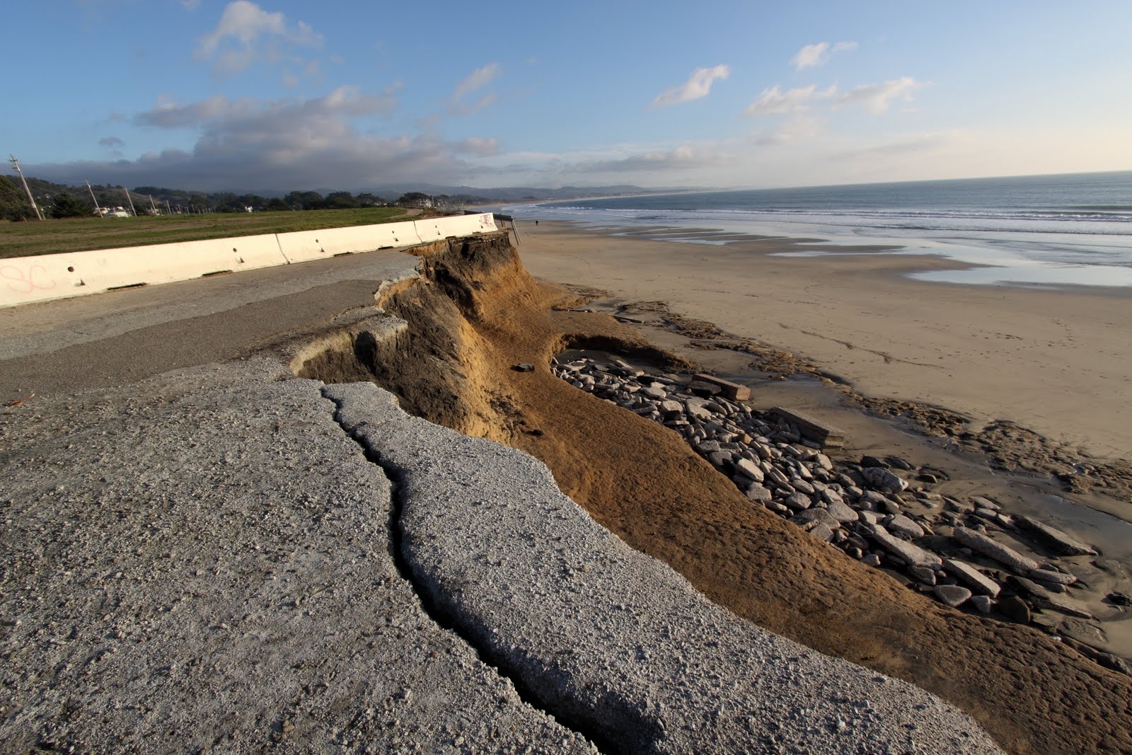
In February of 2010, Chile was hit with a magnitude 8.8 earthquake and ensuing tsunamis that devastated more than 400 miles along the coast and took the lives of many Chileans. Being uniquely positioned to assist with relief efforts following the disasters, last year Save The Waves, spearheaded by my predecessor Josh Berry, delivered supplies and equipment to the Chilean people and assisted with community projects to get people back on their feet. Among other supplies, the Save The Waves team delivered 1,000 water filters that allowed over 10,000 Chileans to have access to clean water immediately after the disaster.

Visiting the region, I completely understood why Save The Waves decided to undertake the relief project. With good-natured and hospitable people and a coastline like this, it was not an option to sit idle. The STW team felt obligated to support the people who have worked with us side by side for the past five years on conservation and water quality issues. The health of the coastal and marine habitat and wildlife also depends on the well-being and vitality of the Chilean coastal communities.


The epicenter of the earthquake was located just off the coast of Cobquecura in the Bíobío region (southwest of Santiago). Tsunami waves headed northeast and southeast of the epicenter, hitting Constitución, Pelluhue, and Curanipe hard in the north and Talcahuano, Dichato, and Concepción in the south. The destruction of the natural disaster is astounding. Countless times my partners would point out what was a structure and now is only dirt. They would say, “There used to be houses here, a restaurant there, or a theater was over there.” In Constitución, at the mouth of the Maule River communities built on the southwest banks were completely washed away.

One year later, many of the affected towns are still struggling to recuperate and return to some sense of normalcy of life before the earthquake. Communities are rebuilding, although some people are still living in camps that were meant to be temporary. Seeing the aftermath of the disaster still an everyday reality one year later, my thoughts turned to the current situation of the people of Japan who were hit by a worse fate just days before my trip to Chile.

While immediate needs understandably have taken priority following the earthquake and tsunami, water quality remains an issue for the coastline where industrial giants rule the land. In 2008, Save The Waves, having worked in the region for years, founded the Maule Itata Vigilante Costero (Coastkeeper), in partnership with the environmental legal nonprofit FIMA. The mission of the Maule Itata Coastkeeper is to monitor the quality of water along this region from the Maule River to the Itata River, along Chile south central coast. Rodrigo de la O works to monitor the coast, provide environmental education, and to build the local community’s capacity to serve as advocates on water quality issues. Charismatic, humble, and passionate, Rodrigo works with the local community to protect the Maule and Bíobío region’s coastal heritage.

In 2006, despite vehement opposition from Save The Waves and local groups like Salvemos Cobquecura, a new pulp mill plant owned by the company CELCO was constructed in the valley of the Itata River. The plant, the Nueva Aldea Forestry and Industrial Complex, is the largest plant of its kind in the county with the capacity to produce more than 800,000 tons of bleached pulp per year. Originally dumping waste directly into the Itata River, CELCO constructed a 50-kilometer pipeline, completed three years after the plant’s opening in 2009, to carry the plant’s effluent underground through the region’s agricultural lands and out into the ocean. This effluent carries the byproducts of pulp production, which includes the use of chlorine to bleach the pulp leaving highly toxic organochlorines like dioxins and furans. Standing at the mouth of the river near the last section of the duct, the earth trembles from pumps underground forcing the waste into the ocean. This waste is deposited into the ocean along a stretch of perfect left point breaks that dominate the region.

North of the Nueva Aldea plant, Constitución, once called the Pearl of Maule, is a town that has been living with the realities of pulp mill production since the late 1960’s. The pulp mill plant occupies prime coastline of the town and emits fumes that burn your eyes and nostril, reeking of toxic cabbage. A friend traveling with us, who is from Constitución, shows us the best place to get a birds eye view of the plant and points to an open space on the hill and says, “This is where we played as kids.” The consent amongst the townspeople is that air quality is now better following the installation of several air filters. Downwind of the plant, I couldn’t imagine what it was like before.

These plants transform pine and eucalyptus and into wood products and pulp to be later processed at paper plants. In the northwestern coastlines of the region BioBio and Maule, the forestry industry owns a great majority of the coastal and adjacent land where Pine and Eucalyptus, both exotic, highly invasive, quick-growing, and water consuming species. According to the World Wildlife Foundation, from 1985 to 1995, Chile lost nearly 2 million hectares of native forest, decimating local ecosystems and biodiversity.

Despite the forestry/pulp mill industry’s intent to turn the land into a profit machine, the coast is breathtaking with grasslands and forests with a rocky coast along perfect left point breaks stretching down every few kilometers. Pockets of wetlands and native Maule coastal forest habitat remain amidst the vast rows of tree farms.

The Mediterranean climate, comparable to that of California, allows small-scale farmers—nearly 1,000 along the valley of the Itata River—to produce grapes, corn, wheat, potatoes, berries and other crops in the fertile lands. Along the rocky coast, artisanal fishermen live of the sea by catching Merluza, Pejerrey, Jaibe, Reineta, Corvina, Congrio, Robalo, Lenguado, and other seafood.


In addition to pulp mill pollution, another threat is lurking in the shadows for this region. A coal-fired project called Los Robles is proposed for coastal land just north of the big wave spot Santos del Mar in the Maule Region. The project entails the construction of a 750-megawatt coal-burning facility and industrial port. Pulverized coal shipments from Australia would be unloaded there, damaging the ecosystem and polluting the ocean with ashes and toxic wastewater.

More than twenty proposals are approved or pending for the construction of similar coal-powered plants throughout Chile, many slated for the coast. Despite this overwhelming number of proposals, community organizing efforts have paid off in other regions like in Barrancones where controversial plans to build a thermoelectric plant near a protected area in the northern Chilean region of Coquimbo were cancelled. This victory illustrates the need to stay united and mobilized to protect the coast and ocean.

Up against powerful polluting industries and a pro-business government that bows to company interests, every day, local and international heroes are working for communities’ rights to clean water and air, as well as the right to a sustainable livelihood. Individuals from groups like the Maule Itata Coastkeeper, Salvemos Cobquera, Accion Ciudadana Pro-Defensa De La Costa Del Maule, Conservación Patagonica, Patagonia Sin Represas, Greenpeace, FIMA, Terram, and many others. In addition to these groups, many everyday residents (fishermen and landowners) have become leaders by drawing a line in the sand, sticking to principal, and refusing to accept bribes to overlook pollution created by powerful companies.

Save The Waves is continuing to work in the region to engage and support community members to participate as advocates to address water quality and coastal conservation issues. Like our colleagues at Maule Itata Coastkeeper say, our movement is about “Aguas Limpias, Communidades Fuertes (clean water, strong communities).” That about sums it up, although I might add “Olas Perfectas” (perfect waves) to the tag line for it to be ideal.

- Katie Westfall, Environmental & Program Director

Monday, March 14, 2011

Santa Cruz, California & Ericeira, Portugal Approved as World Surfing Reserves

World Surfing Reserves announced that two nominated surf zones – Santa Cruz in Northern California and Ericeira in Portugal – have been formally approved and will be dedicated as World Surfing Reserves (WSRs). The two iconic surf regions will join Malibu, California, which was dedicated as the first World Surfing Reserve in October 2010, and Manly Beach, Australia, which was approved in 2010 and is awaiting dedication sometime in 2011, as the first sites to receive the prestigious WSR designation.


Beautiful barrels at Natural Bridges, Santa Cruz.

The Santa Cruz zone, approximately 11 km (7 miles) of coast extending from Natural Bridges on the western end to Opal Cliffs just east of Pleasure Point, is made up of a dense collection of cold-water dream waves and is steeped in surfing tradition. The zone is best known for the iconic spots at Steamer Lane and Pleasure Point, both world-renowned righthand pointbreaks.

“I can’t think of a more deserving location than Santa Cruz,” said the city’s most notable icon, Jack O’Neill, who invented the surfing wetsuit so he and his friends could surf the frigid waters back in the ‘50s and ‘60s. “It’s got so many amazing surf spots, a wonderful surf community, and it’s just a beautiful stretch of coast. The World Surfing Reserve designation will be a great way to help preserve the area.”


The clean lines of Ericeira, Portugal.

The Ericeira area of Portugal is a surf mecca for Portuguese and international surfers alike. The approved Ericeira surf zone consists of 4 km (2.5 miles) of coastline that contains a highly concentrated group of quality surf breaks, several of them world-class, including the popular Ribeira d’Ilhas and other world-renowned breaks.

“Ericeira is such a diverse surfing coastline, it has something for everyone,” said WCT professional surfer Tiago Pires, who grew up surfing there. “There are big waves, small waves, expert waves, and beginner waves. I love this area, and I’m glad to see it get the recognition it deserves, as well as a tool to help better protect it.”

World Surfing Reserves seeks to designate and protect the most important and cherished surf areas around the world, in partnership with local surf communities. WSR sites are nominated and selected based on four major criteria: quality and consistency of waves, importance to surf culture and history, environmental characteristics, and community support. So far over a hundred sites have been submitted for consideration for WSR status from 34 different countries.

Ten-time World Surfing Champion Kelly Slater, who lent his support to the World Surfing Reserves movement last year, also expressed his strong backing for Santa Cruz and Ericeira. “Any time we have a chance to officially preserve a beach or specific surf break, I'm all for it,” he said. “World Surfing Reserves is setting the bar high and far-reaching by covering the globe with the next group of beaches to be protected. I look forward to the dedications and future protection those beaches – as well as many others – will see.”

Beyond its cultural and aesthetic significance, each WSR is a meeting of land and sea selected for the unique and salutary nature of its waves and natural setting. The dedication of each WSR seeks the protection of this coastal zone of waves and habitat from inappropriate development, through international and local partnership that builds community around conservation, to improve and dictate stewardship of the area.

About World Surfing Reserves

World Surfing Reserves (WSR) proactively identifies, designates, and preserves outstanding waves, surf zones and their surrounding environments, around the world. WSR is an initiative launched by Save The Waves Coalition in 2009 in conjunction with National Surfing Reserves - Australia, and through additional partnerships with the International Surfing Association (ISA) and Stanford University’s Center for Responsible Travel (CREST).

For more information: www.worldsurfingreserves.org