Wednesday, June 29, 2011

The Search for Solutions to Erosion Issues at Surfer's Beach


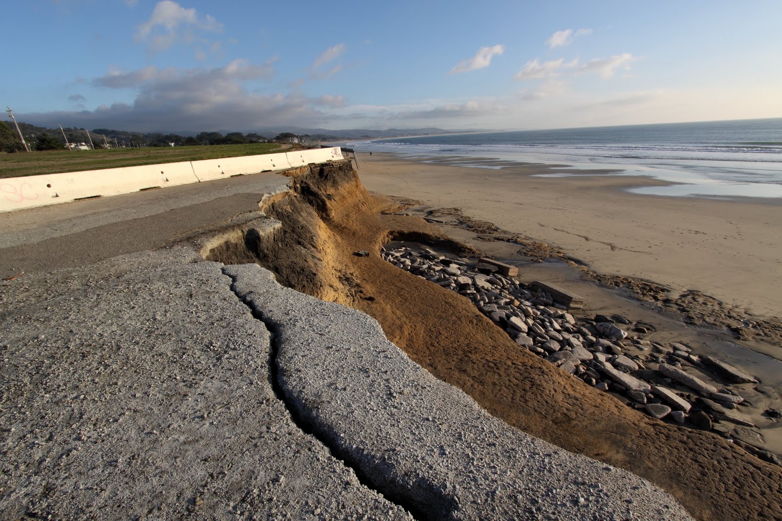
Photo of Surfer's Beach by Brian Overfelt

Efforts continue to find solutions to protect Surfer's Beach in Half Moon Bay, California. The construction of a breakwater to create the harbor in 1961 has exacerbated erosion rates by causing more sand to be deposited on the harbor side. Now only a thin strip of beach remains at Surfer’s Beach, limiting recreational uses of the beach, threatening habitat for the federally threatened western snowy plover, and eroding away the embankment of Highway 1.

Several possible solutions have been looked at, including building an artificial reef, poking a hole in the breakwater to see if circulation could be restored, building a small structure to trap sand and hall it away, and dredging. In order to discover whether any of these options would actually help the problem, the U.S. Army Corps of Engineers have first planned a study that takes into account all the factors that are causing the erosion. The impacts of these possible solutions have also yet to be assessed.

To establish baseline conditions for this study, the engineers partnered with the U.S. Geological Survey to disperse tide gauges and buoys to collect information about the wind, waves, and water to help them understand the problem and how to solve it. The Corps of Engineers, in partnership with San Mateo County Harbor district, presented these baseline conditions at a recent public meeting on June 6, 2011 in order to gain local community and general public input on the problem.

The engineers will spend the summer analyzing data and calibrating a model of Surfer’s Beach, and then later this year will propose alternatives for the beach to the community.

Thursday, May 5, 2011

Keep Following Us on Facebook

One of the recent changes to Facebook is the new limited newsfeed feature. You may have noticed that you are only seeing updates in your newsfeed from a few people, and that, whilst the same circle of people are commenting on your news, everyone else seems to be ignoring you. Well, the likelihood is that no one has actually blocked you. "New Facebook" has a newsfeed setting that, by default, is automatically set to only show people you've interacted with recently. Any other friends are now invisible to you and you to them.

TO FIX THIS:

Scroll down to the bottom of the Newsfeed on your HOME page and click on "Edit Options". In the popup, click on the dropdown menu next to 'Show posts from:' and select "All Of Your Friends and Pages" and then click Save.

By doing this, you will receive newsfeeds from all your friends and pages. This will ensure that you will receive important updates about protecting coastlines and the ocean worldwide from Save The Waves.

Tuesday, May 3, 2011

Save Sloat!!!


The original Strategic Relocation vision from the Ocean Beach Task Force 2002: Courtesy of Brad Evans and Bob Battalio of Phillips Williams and Associates.

Information courtesy of Bill McLaughlin of Surfrider San Francisco

As has been done throughout the world, the City of San Francisco has been developed right up to the edge of the coastline in Ocean Beach. The bluffs have been eroding slowly over time, but early in 2010, much of California was battered by a series of powerful winter storms. Coastal erosion was widespread. At Ocean Beach, the area south of Sloat Boulevard was hit particularly hard. Up to 30 feet of sandy bluff washed away exposing large amounts of concrete debris. The southbound lane of the Great Highway was undermined and fell off the cliff onto the beach.

On January 15th a declaration of emergency was issued by the SF Department of Public Works (SFDPW) to protect City infrastructure in area. In addition to the Great Highway, a wastewater tunnel that runs underneath that road was thought to be in danger of being unearthed. Acting under emergency powers, the agency began construction of a 440 foot long wall of boulders (or rock revetment) to halt the erosion and to protect the tunnel and what remained of the road. Surfrider Foundation San Francisco Chapter and Save the Waves Coalition joined forces to oppose the revetment and have argued the need for a more sustainable long-term plan.

So now, engineers under the SPUR Master Plan and key city officials are beginning to form alternative long term plans for Sloat Erosion. The next public workshop which will offer citizens an opportunity to weigh in on this issue will be June 4. Location TBA. In the meantime Surfrider San Francisco would like to begin a deeper discussion of our preferred plan: Strategic Relocation (also known as Managed Retreat). Below is a series of links in which Strategic Relocation was used to respond to coastal erosion events in California. These three examples involve public infrastructure that was being threatened by an encroaching high tide line, as well as the need to remove fill/rubble and add sand in its place. Note the 2 local projects. Successful examples of this strategy are found in our own backyard...

MAKING THE CASE FOR STRATEGIC RELOCATION (CLICK THE LINKS BELOW):

SURFER'S POINT - Ventura, Ca:
SURFER'S POINT (PWA PROJECT WEBSITE)
SURFER'S POINT (NOAA WEBSITE)
SURFER'S POINT (SURFRIDER WEBSITE)
SURFER'S POINT (VENTURA RIVER WEBSITE)

PACIFICA STATE BEACH (Lindamar) - Pacifica, Ca
PACIFICA STATE BEACH (PWA PROJECT WEBSITE)

CRISSY FIELD - San Francisco, Ca
CRISSY FIELD (PWA PROJECT WEBSITE)

Tuesday, April 26, 2011

+ LIFE IS A WAVE 2011 +

111 Minna Gallery - San Francisco - June 10, 2011

Thursday, April 7, 2011

A Few Minutes Could Help Save Two Irish World-Class Breaks


Photo of Crab Island by Mickey Smith.

The fight continues to save Doolin Point and Crab Island. Despite the recent approval by the Clare County Council to build a pier that threatens the world-class waves of Crab Island and Doolin Point, the project now must acquire a foreshore license by the Department of the Environment, which is being applied for now. Please urge the Department of the Environment to rethink this project. Letters must arrive before the 21st of April, so don’t wait. Send you letter today! See guidelines below.


The Foreshore Unit,
Department of Environment, Heritage, and Local Government,
Newtown Road,
Wexford.
Ireland


Date: ____________

Re: Section 19 of the Foreshore Act, 1933. Clare Co. Co. application to Mr. Phil Hogan T.D., Minister for the Environment, Heritage & Local Government for permission to occupy an area of foreshore at Doolin, Co. Clare for the purpose of constructing an access road, pier structure and associated dredging works at Doolin Pier, Doolin, Co. Clare.
Ref: MS/51/11/234

Dear Sir/Madam,

The following points are of concern and we would ask each of you to choose some of these points and maybe add some additional issues of your own, elaborate upon them with a few sentences and submit to the above address by post to arrive before 21st April 2011. The following points are the opinion of the West Coast Surf Club in light of our assessment of the proposed development:

• The new pier structure has the potential to destroy a highly regarded surfing wave at Doolin Point and potentially have a significant impact on the surfing quality of the world renowned wave at Crab Island.
• The new pier structure will be located where surfers currently safely access the water. The new development will result in a significant danger to surfers as they will have to enter the water at either the shore side of the pier, crossing the ferry paths, or at the seaward side of the pier where the reef is extremely dangerous and this will be compounded with the backwash from the new pier.
• The proposed pier, as designed, will create significant currents in the water in and around the area where surfers paddle. This will create a serious health and safety hazard and surfers may be dragged onto rocks, the new revetment or into the paths of ferries.
• The proposed pier is of an extremely large scale which will be visible from many surrounding areas, in particular the renowned views of the point from the hills to the south.
• The pier will involve significant blasting and dredging of the seabed. The full impacts that these activities will have on the environment in and around the subject site have not been assessed appropriately. The works will have potentially disastrous repercussions for different aquatic species in the area including dolphins. A full Environmental Impact Statement should be prepared.
• The pier requires a new tarmac access road which will be constructed on the existing limestone pavement at Doolin Point.
• The development could have a significant impact on the amenity value of the Doolin area for surfers, sightseers, walkers, bird watchers, hikers, due to its size, and location.
• There is a need for a new pier. However, a design which will not have the above negative impacts can be provided and should be designed as an alternative to the current proposal.

The above points are to guide you in your submission. However, we would ask you to make your submission as personal and unique as possible. Please include your full address in the submission.


Follow this effort on the "How You Can Help Save Crab Island" Facebook page.

Contact the West Coast Surf Club at info@westcoastsurfclub.com for more information.
Sunday, April 3, 2011

Will Peru Take the Final Steps to be a Global Leader in Surf Spot Protection?


Photo: Leonel Romero

Ten years ago the Peruvian Government passed Law 27280, the Law for the Preservation of Waves. This world’s first federal law that specifically protects surf spots actually includes an official registry of waves, listed by geographic coordinates, and these waves are protected from physical harm under this law.

However, this important law hasn’t gone into effect yet. For the law to be implemented, several ministries, federal agencies, and institutions must “approve” its language and enshrine it as the rule of the land. As a consequence, Peruvian waves are still facing constant threats.


Photo: Web ISA

Peru is blessed with a coastline of world-class breaks, some of the top surfers on the globe, a vibrant surf culture, and a fascinating surf history. Many Peruvians have recognized the importance of protecting the coastline to not only preserve Peru’s heritage, but also for the country’s economy. Peru has become a top surf destination, with national and international surfers chasing swell up and down the coast.


To keep the pressure on the Peruvian government to implement Law 27280, more than 100 surfers and body boarders recently paddled out at Playa Waikiki in Miraflores, Lima to ask authorities to implement Law 27280. Check it out:


FENTA, Sociedead Peruana de Derecho Ambiental, and Save The Waves will continue to urge the Peruvian government to protect its breaks by implementing this landmark legislation.